Signal Optimized Land Acquisition (SOLA)
Compensating for irregular access, costs and noise to gather more actionable data
Optimizing acquisition
Powerful software drives our Signal Optimized Land Acquisition (SOLA) and optimization processing. It seamlessly integrates with ACTeQ’s TesserACT survey design and optimization package, so noise and cost function maps can be used to optimize cost and quality. This new survey design tool overcomes traditionally problematic issues, including noise, no go areas, variable access costs and complex designs.
Land Seismic Noise Specialists custom design surveys to gather only high-quality data. We optimize source and receiver geometry to block out noise across each survey, resulting in uniform noise-correction at the lowest possible cost.
Tenfold variation in noise and irregularity isn’t uncommon — but it makes the final image 100 times less useful. Noise holes like these are created when a survey is either over- or undershot. That’s because optimizing source and receiver geometry is a large, demanding inversion problem.
LSNS has proprietary technology, along with the necessary expertise, to routinely and successfully perform these optimizations.
To learn more about our process, see the January 2023 First Break article: Using ‘Noise-Corrected OVT Fold’ to optimise land seismic acquisition risk, costs, and quality
Unmatched noise-correction
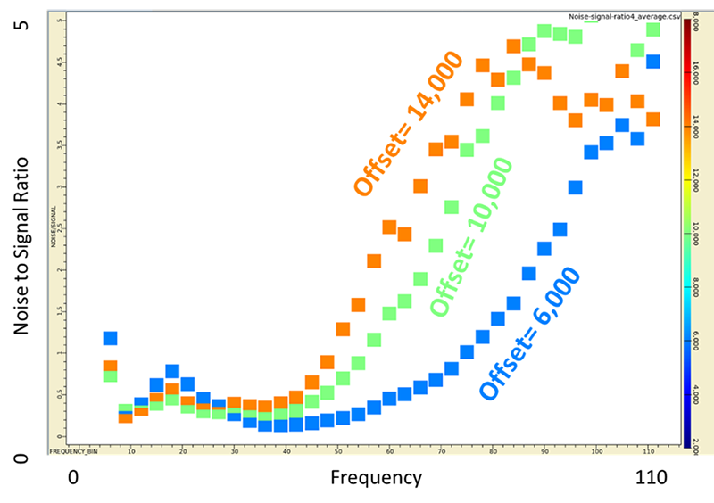
Data quality varies significantly with frequency and offset.

Global and local optimized layout: Optimized receiver layout with cross-line receivers.
Survey planning
We leverage irregular factors to save you time and money
Our game-changing SOLA technology allows Land Seismic Noise Specialists to custom design surveys with global and local optimization, accounting for every variable. This means you can take advantage of the irregular factors that often stymie other companies.
Preliminary results are refined based on your feedback, and we give you the choice of layout.
Our methodology can save 10% to 60% on acquisition costs, while ensuring your seismic data meets your imaging goals.
Typical layout scenario options, which can be tailored to meet your needs, include:
Optimization for acquisition and imaging only, not taking into account noise maps (baseline)
Optimization accounting for noise without adding any source/receiver locations
Optimization accounting for noise adding up to 10% more source and receiver locations
Noise Analysis and Survey Optimization Procedure
Phase I: Analyze existing data and design field test.
Phase II: Analyze and process field test, make recommendations for regular 3D acquisition.
Phase III: Use the results of Phases I and II in combination with satellite data and LIDAR to recommend acquisition enhancements.

What we need from you:
→ GIS or grid maps of access constraints for sources and receivers. This can be no-permit areas, topography, exclusion boundaries around structures, etc.
→ GIS or grid maps of costs of placing sources and receivers in different locations. This can be where vibes can access, where heli-support is necessary, where foot access is difficult, etc.
→ GIS or grid maps of roads and other cultural noise generators. Roads and industry can cause a lot of noise.
→ Nearby legacy data that can be used for prestack noise analysis.
→ Maps of surface geology that you can expect to influence noise. Noisy areas may be thick, unconsolidated sediments, very shallow water tables and sand dunes. Good areas may be agricultural fields, shallow bedrock, homogeneous near surface.